GTA 6 map: Leonida, Vice City and the 6 regions Rockstar has shown
Rockstar has already put six big names on Leonida. The poster added a few more for a few hours. Then the image changed: the islands stayed; the names didn't.
- State
- LEONIDA
- Regions
- 6
- City
- VICE CITY
- Official size
- NOT GIVEN
- Confirmed
- Unconfirmed
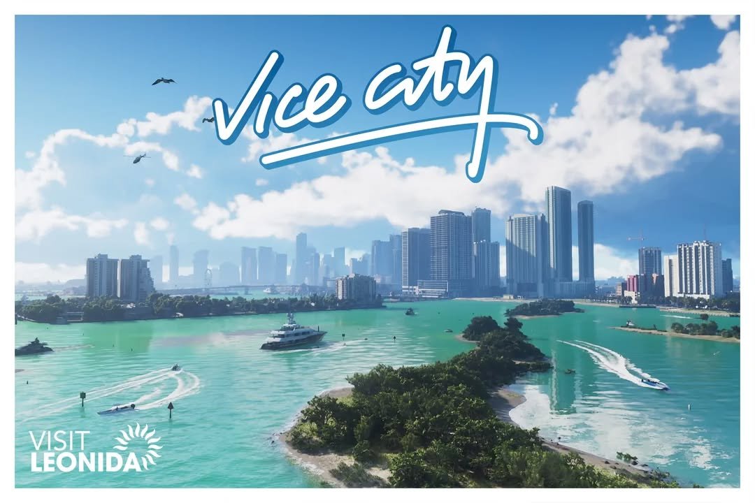
The GTA 6 map is Leonida.
Vice City takes up one part of it. Leave the city and you get the Leonida Keys, Grassrivers, Port Gellhorn, Ambrosia and Mount Kalaga National Park.
Six big names Rockstar has placed on the state.
Since September 24 there’s another piece on the table: an official Leonida poster that, for a few hours, showed several labels over a group of islands.
Then Rockstar swapped the image.
The islands stayed. The names didn’t.
What official GTA 6 map exists so far
Rockstar includes a double-sided poster in The Goodtime State – Vice City Collection.
The store itself describes one side as a full view of Leonida’s landscape.
So we already have an official map of the state.
What’s still missing is the map you’d use to find your way in the game: full roads, clear borders, distances and a scale to measure Leonida with.
That’s where the community reconstructions come in.
One comes from Rockstar.
The other gets pieced together from the material Rockstar keeps releasing.
Best not to put them on the same map.
The six main regions Rockstar has shown
Vice City
This is the big city.
Beaches, hotels, skyscrapers, residential neighborhoods, highways and neon streets are spread across the official material.
Vice City is back.
But this time the map keeps going when the city ends.
Rockstar sets the story inside a much bigger state.
Vice City takes up one part of the map.
Leonida keeps going when the city ends.
Leonida Keys
Road. Bridge. Water on both sides.
The Keys run a road between islands: houses by the sea, boats and miles of asphalt from key to key.
The Florida Keys inspiration is right there in the name and in the landscape.
Rockstar also ties this area to Brian Heder, a veteran smuggler who still runs his operation out of his boatyard.
Grassrivers
Here the ground starts filling up with water.
Mangroves. Shallow water. Alligators. Birds.
Airboats cutting through the wetland.
That’s Grassrivers.
The visual comparison with the Everglades is obvious, although Rockstar hasn’t presented Grassrivers as an exact copy of the real park.
Leonida is still a fictional geography built from Florida.
Port Gellhorn
Leave the wetland and the landscape changes again.
The buildings get lower.
Motels, parking lots, shops and open road show up.
Rockstar presents Port Gellhorn as a coastal town far from the shine of Vice City.
The big city falls behind.
The road keeps going.
Ambrosia
Ambrosia pulls the map inland.
The official images show industry, fields and the Allied Crystal sugar refinery.
There are bikers in the area too.
Beach behind you. Islands behind you. Wetland behind you.
Now come factories and inland roads.
Mount Kalaga National Park
To the north, the forest.
Rockstar has shown Mount Kalaga National Park with dense vegetation, high ground, roads through the trees and activities tied to hunting, fishing and off-road vehicles.
Here the Vice City postcard is harder to see.
Six names.
City, keys, wetlands, coast, industry and national park.
That’s what Rockstar has placed on Leonida so far.
The poster showed new names and then lost them
On September 24, Rockstar announced The Goodtime State – Vice City Collection.
Among its eleven items is a Leonida poster printed on both sides.
The first photo had something the current one lost.
There were names over several islands.
Outlets like Notebookcheck and Dexerto were able to read two in full:
Sandbars.
Crude Islands.
There were also two partial labels starting with “Dra…” and “Beld…”.
Then Rockstar changed the store image.
The islands stayed. The names didn’t.
Rockstar hasn’t explained the change.
Those names were on official material.
That still doesn’t make them locations Rockstar has confirmed for the final game.
The “Dra…” label has been linked to Draper Island, a name the community spotted in material tied to Port Gellhorn.
That connection is still a community interpretation.
The poster’s before and after also appears in our guide to the $399.99 GTA 6 collection.
State of Leonida rebuilds the map before launch
Until Rockstar publishes the detailed playable map, the community works with the pieces as they appear.
One of the main projects is State of Leonida.
Its reconstruction was at version 16.0, updated September 20, 2026, when we last checked.
A road shows up behind a character.
A building appears from another angle.
A bridge slips into a screenshot.
A coastline peeks out of a trailer.
The pieces start to fit.
Then Rockstar releases another image.
You move a road. You shift a coastline.
The whole map rearranges behind it.
That’s why State of Leonida is useful for seeing how the world might be laid out before launch.
A reconstruction can get very close and still not be the map Rockstar puts in your hands.
Vice City doesn’t cover all of Leonida
Leonida is the state.
Vice City is inside it.
Jason and Lucia will also move through other places, and the official site itself presents destinations outside the city.
You leave Vice City.
You cross the Leonida Keys.
You head into Grassrivers. And Leonida keeps going. The city ends. The map goes on.
Leonida is built on Florida
The Florida reference is plain to see.
Vice City takes much of Miami’s visual identity.
The Leonida Keys point to the Florida Keys.
Grassrivers uses wetlands, mangroves, alligators and airboats that call up the Everglades directly.
From there, the matches get less clean.
Port Gellhorn borrows from coastal towns.
Ambrosia takes the map toward industry and the interior.
Mount Kalaga brings in a more wooded, higher north.
Florida is the ground. Leonida rearranges the pieces.
How big is the GTA 6 map
We stop here.
Rockstar still hasn’t put an official square-kilometer figure next to Leonida.
Change the map, the version or whether you count water and land, and the number changes too.
That’s why the numbers have their own guide:
GTA 6 map size: how big Leonida is compared with GTA 5.
There we separate the comparisons attributed to Rockstar, the derived calculations and the community map measurements.
Online doesn’t fill in the map yet either
Rockstar hasn’t explained how much of Leonida its future multiplayer will use.
We don’t know whether Online will open all of Leonida on day one, only part of it, or whether the world will grow over time.
The map existing for the story doesn’t automatically draw the one for Online.
GTA 6 multiplayer still has no official date, final name or full reveal.
What isn’t confirmed
Rockstar still hasn’t published a detailed playable GTA 6 map with all its roads, borders, names and distances readable.
Sandbars and Crude Islands appeared labeled on an official image that was later changed, but Rockstar hasn’t formally presented them as new areas of the game.
The full names behind the “Dra…” and “Beld…” labels aren’t confirmed either.
State of Leonida is a community reconstruction. Its positions and borders can change as new material comes out.
Rockstar also hasn’t published Leonida’s official size in square kilometers.
And it hasn’t said whether the map will grow after launch.
GTA 6 launches on November 19, 2026 on PS5 and Xbox Series X|S.
Primary sources: Rockstar Games, Grand Theft Auto VI: Only in Leonida, official screenshot gallery, The Goodtime State – Vice City Collection announcement and official collection listing.
Community source: State of Leonida, version 16.0 when last checked.
Secondary sources: Notebookcheck and Dexerto for the labels visible in the first promotional image of the poster and their later removal.
Last checked: September 27, 2026.