GTA 6 in Real Life: The Extended Look Locations in Miami
We followed the Extended Look through real Miami. Bridges, hotels, a Walgreens, the famous clock building, the airport and even buildings Rockstar moved several miles.
The GTA 6 Extended Look drives through streets, bridges and past buildings you can search for in Miami right now: Venetian Causeway, MacArthur Causeway, Ocean Drive, 10th & Alton Road, Lincoln Road, Miami River, Miami International Airport and Biscayne Boulevard. Rockstar recreates some buildings in remarkable detail, then moves the pieces around to build Vice City. This guide follows the Extended Look in order. When the same location also appears in Trailer 1 or Trailer 2, we add those labels to the same entry. Each stop includes a real address or area so you can open it directly in Google Maps or Apple Maps and compare it yourself.
How we checked these GTA 6 locations
The main route was cross-checked against two videos by Miami-based creator Joel Franco. First, he reacted to the Extended Look as a local, recognizing roads and buildings he regularly drives or walks past. Then he went outside and checked many of them in person. He drove the routes, filmed with a 360 camera, walked the streets and flew a drone over several locations to recreate Rockstar’s angles. That also makes the changes easier to see. A building sits three blocks farther south in real life. A skyscraper moves about six miles. A street continues in Vice City even though the real one ends. Some buildings in GTA 6 no longer exist in Miami at all. Rockstar has not published an official building-by-building list connecting GTA 6 locations to real Florida addresses. The matches below are based on visual comparison, geography, local knowledge and community mapping.
Watch Joel Franco retrace the GTA 6 Extended Look through Miami
Joel Franco lives in Miami and physically revisited many of the locations shown in the Extended Look. He drives Venetian Causeway, MacArthur Causeway, Alton Road, Washington Avenue, Lincoln Road and Biscayne Boulevard, visits the apartment site, checks the Miami River and Downtown, and uses a drone to compare several Rockstar shots with the real city.
Video: Joel Franco — GTA 6 Extended Look locations in real life · Channel: Joel Franco on YouTube
1. Lucia and Jason’s apartment → Edgewater
EXTENDED LOOK
Confidence: very high · checked on location
The building Rockstar appears to have used for Lucia and Jason’s apartment has already been demolished. Joel visits the site and uses the green-columned building still standing across the street to reconstruct where their balcony would have been. Community mapping has identified the demolished building as the former Belmar Condominium in Edgewater.
Historic location: around 419 NE 19th Street, Miami, FL
GTA 6 preserves a piece of Miami that is already gone.
2. Leaving the apartment → Edgewater toward Venetian Causeway
EXTENDED LOOK
Confidence: very high · route driven in person
Jason and Lucia leave the apartment and drive past the green building that can still be seen across from the former apartment site. The real route heads south from Edgewater toward the Venetian Causeway. The Metromover appears around this area too, although Rockstar adjusts its path to fit Vice City.
3. Venetian Causeway → Venetian Causeway
EXTENDED LOOK TRAILER 2 TRAILER 1
Confidence: very high · checked on location
There is very little guesswork here. One lane in each direction. Green bike lanes. Low bridges. Small islands. Biscayne Bay on both sides. Joel drives across the same causeway used by Jason and Lucia.
Real location: Venetian Causeway, Miami / Miami Beach
The Extended Look returns here later for the toll gantry.
4. Ocean Drive → South Beach
EXTENDED LOOK TRAILER 1
Confidence: very high
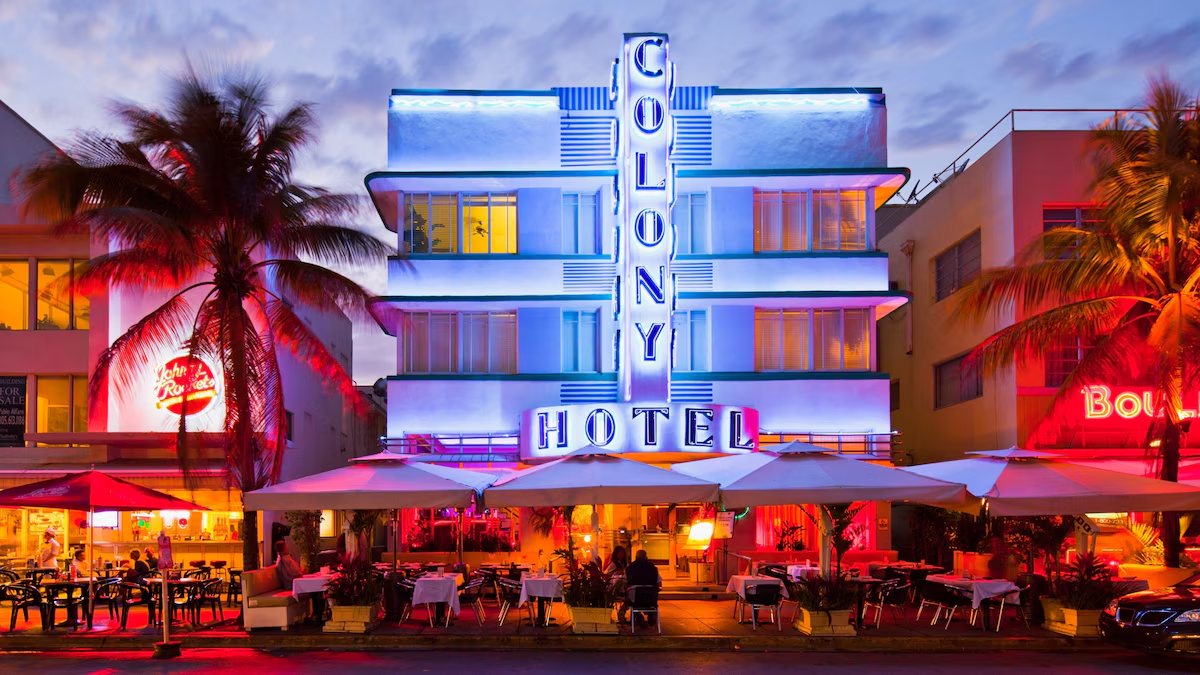
Neon. Art Deco hotels. Palm trees. Cars running along the beachfront. This is Ocean Drive. There is also a useful clue to when Rockstar collected its reference material. GTA 6 shows two-way traffic. Ocean Drive used to work that way, but its layout changed after the pandemic and part of the road space became a protected bike lane.
Real location: Ocean Drive, Miami Beach, FL
5. Cortez Hotel → Ocean Drive architecture
EXTENDED LOOK
Confidence: high
During his reaction, Joel connects the Cortez Hotel to the architecture of Ocean Drive, particularly the Colony Hotel. The vertical signage, facade and position within the Art Deco strip make it a strong visual reference.
Real area: Ocean Drive, Miami Beach
6. Lummus Park → Lummus Park
EXTENDED LOOK TRAILER 2
Confidence: very high
Several beach and promenade shots match Lummus Park, which runs alongside Ocean Drive. Joel recognizes the area immediately while watching the Extended Look.
Real location: Lummus Park, Miami Beach
7. Effluvia → Juvia at 1111 Lincoln Road
EXTENDED LOOK
Confidence: very high · checked by drone
The on-location video makes this match much stronger. Joel flies over 1111 Lincoln Road and recreates the angle from the Extended Look. The rooftop space, railing, retractable cover and South Beach backdrop all line up. When Rockstar collected its references, the rooftop restaurant here was Juvia. It closed in 2023.
Real location: former Juvia
Address: 1111 Lincoln Road, Miami Beach, FL 33139
Other community maps have proposed another nearby rooftop. Joel’s physical comparison fits Juvia particularly well.
8. Lincoln Road → Lincoln Road
EXTENDED LOOK
Confidence: very high
You can see Lincoln Road behind the Effluvia scene. Trees. Shops. Restaurants. Pedestrian space. Joel shows the same axis from above and explains how it runs across South Beach.
Real location: Lincoln Road, Miami Beach
9. Lucia with the duffel bag and Jason on the bike → 41st Street
EXTENDED LOOK
Confidence: very high · checked on location
Lucia runs out carrying a duffel bag while Jason waits on a motorcycle. The scene has been placed on 41st Street, also known as Arthur Godfrey Road. The arched building in the background helps identify the corner. Joel also points out the real Wells Fargo at the intersection.
Real area: 41st Street / Chase Avenue, Miami Beach
10. MacArthur Causeway → MacArthur Causeway
EXTENDED LOOK
Confidence: very high · route driven in person
The Extended Look also uses MacArthur Causeway. Joel drives the real route with a 360 camera mounted on the car. PortMiami and the cruise ships sit on one side. Miami Beach is ahead. Rockstar also compresses the road itself. Parts that have three lanes in real life appear with two in GTA 6.
Real location: MacArthur Causeway, Miami
11. Starfish Island → Star Island
EXTENDED LOOK
Confidence: very high
A sign for Starfish Island appears from MacArthur Causeway. Miami has Star Island, known for large waterfront mansions and the sightseeing boats that circle it. Rockstar barely has to touch the name.
Real location: Star Island, Miami Beach
12. Entering South Beach → 5th Street and Alton Road
EXTENDED LOOK
Confidence: very high · route driven in person
At the end of MacArthur Causeway, signs point toward Alton Road and the Art Deco Historic District. The large parking and retail complex shown in GTA 6 exists. The real building contains parking and several stores. One major part of today’s skyline is missing: Five Park had not been completed when Rockstar gathered much of its reference material. GTA 6 shows a crane in that area. That does not prove the tower will eventually rise during the game. It does give us another clue about the version of Miami Rockstar photographed.
13. The chase begins → 10th & Alton Road
EXTENDED LOOK
Confidence: very high · checked on location
This is where the route gets especially useful. The chase runs through 10th Street and Alton Road. There is a Walgreens on the real corner. GTA 6 also puts a pharmacy there with a very similar building shape.
Real area: 10th Street & Alton Road, Miami Beach
14. The tall building behind the pharmacy → 7th & Alton Road
EXTENDED LOOK
Confidence: very high · checked on location
A tall building appears behind the pharmacy during the chase. It exists. In real Miami, however, it sits roughly three blocks farther south, around 7th & Alton Road. Rockstar moves it closer to 10th Street.
Real area: 7th Street & Alton Road, Miami Beach
This is one of the clearest examples of how Vice City works: real buildings, new distances.
15. Miami Beach Police Department → Washington Avenue
EXTENDED LOOK
Confidence: very high · checked on location
The same chase passes a building with a very distinctive window pattern. It matches the Miami Beach Police Department. The real building sits several blocks away from where GTA 6 places it during the chase.
Real location: Miami Beach Police Department
Address: 1100 Washington Ave, Miami Beach, FL 33139
16. Old City Hall → Miami Beach Old City Hall
EXTENDED LOOK
Confidence: very high
A moment later, a Mediterranean-style building appears. It is Miami Beach Old City Hall. In real life, Old City Hall sits essentially beside the police department. GTA 6 separates them during the chase.
Real area: Washington Avenue, Miami Beach
17. The alleys → South Beach
EXTENDED LOOK
Confidence: high regional match
The chase dives into several alleys. Joel points out that South Beach has plenty of these narrow routes between hotels, shops and other buildings. Rockstar appears to build the sequence from several pieces rather than reproducing one continuous real-world alley.
18. The black building with the clock → 407 Lincoln Road
EXTENDED LOOK
Confidence: very high
This is one of the best details in the entire chase. A dark building appears with a clock on top. It exists. It is 407 Lincoln Road, at Lincoln Road and Washington Avenue. The rooftop clock is a recognizable Miami Beach landmark and alternates between the time and temperature. Joel recognizes it during his first reaction, then later drives the same stretch of road.
Real location: 407 Lincoln / Clock Tower Building
Address: 407 Lincoln Road, Miami Beach, FL 33139
19. The building across from it → former Surf Style
EXTENDED LOOK
Confidence: very high · checked on location
Another recognizable building appears on the opposite side of the same stretch. When Rockstar surveyed the area, the storefront was Surf Style. Today it is a Raising Cane’s.
Current address: 1651 Washington Ave, Miami Beach, FL 33139
GTA 6 preserves an older version of this corner.
20. Collins Park and The Bass
EXTENDED LOOK
Confidence: very high · checked on location
The chase then makes another geographic jump. We see Collins Park and The Bass. Joel drives to the real location and shows how Rockstar has reorganized the road. In Miami, the street ends a few blocks later. In Vice City, it keeps going.
Real location: The Bass / Collins Park, Miami Beach
21. Vice Pass → Venetian Causeway toll gantry
EXTENDED LOOK TRAILER 2
Confidence: very high · checked by drone
We return to Venetian Causeway. Four lanes. Arches. A roof over the road. Bike lanes. The real toll system is SunPass. Rockstar turns it into Vice Pass. Joel flies his drone beside the gantry and recreates the aerial shot from the Extended Look.
22. Lucia’s parachute jump → Jade Ocean
EXTENDED LOOK
Confidence: very high · checked by drone
Rockstar moves a much bigger piece here. The tower Lucia jumps from is Jade Ocean in Sunny Isles Beach. Joel flies to the real building and compares the pool shape, curved tower and top-down geometry. The landscape underneath Lucia, however, is based on Miami Beach. The real tower sits several miles farther north.
Real location: Jade Ocean
Address: 17121 Collins Avenue, Sunny Isles Beach, FL 33160
Rockstar needed a taller tower for the jump. So it brought one south.
23. The kayak scene → Miami River
EXTENDED LOOK
Confidence: very high · checked on location
Lucia appears kayaking with highways and towers around her. The location is Miami River, close to the I-95 overpass with Brickell in the background. Joel makes another useful local observation: he lives in Miami and says seeing someone kayak through this particular stretch is unusual because of the amount of boat traffic.
Real location: Miami River / I-95, Miami
24. Vice City International Airport → Miami International Airport
EXTENDED LOOK
Confidence: very high
The terminals, control tower and surrounding skyline point to Miami International Airport. Joel recognizes it as soon as the airport sequence appears.
Real location: Miami International Airport
25. Autograph Aviation → Signature Aviation
EXTENDED LOOK
Confidence: very high
Inside the airport sequence we see Autograph Aviation. The reference to Signature Aviation is already visible in the name. Signature → Autograph. The terminal and hangar layout strengthen the match.
Real location: Signature Aviation, Miami International Airport
26. The baseball stadium → loanDepot Park
EXTENDED LOOK
Confidence: high
One of the montage shots shows a stadium Joel identifies as loanDepot Park, home of the Miami Marlins.
Real location: loanDepot Park, Miami
27. Mega Mundo → One Biscayne Tower
EXTENDED LOOK
Confidence: very high
Mega Mundo combines two references. The fictional company plays with Miami’s Spanish-language television world and strongly evokes Telemundo. The building itself is a separate match. The tower has been identified as One Biscayne Tower on Biscayne Boulevard. Joel physically drives past it during his real-life recreation.
Real location: One Biscayne Tower
Address: 2 S Biscayne Boulevard, Miami, FL
28. InterContinental Miami
EXTENDED LOOK TRAILER 2
Confidence: very high
Another easy landmark sits nearby: InterContinental Miami. In the Extended Look shots it also helps place Mega Mundo, Biscayne Bay and the surrounding Downtown skyline.
Real location: InterContinental Miami
Address: 100 Chopin Plaza, Miami, FL 33131
29. Biscayne Boulevard → Biscayne Boulevard
EXTENDED LOOK
Confidence: very high · route driven in person
The big nighttime chase near the end runs along Biscayne Boulevard. Joel later drives the same route during the day. Mega Mundo falls behind. Then come Bayfront Park. Bayside. The Ferris wheel. The former Holiday Inn. And finally the arena.
Real location: Biscayne Boulevard, Downtown Miami
30. Bayside Marketplace and the Ferris wheel
EXTENDED LOOK
Confidence: very high
The waterfront Ferris wheel is Skyviews Miami, beside Bayside Marketplace. It is one of the easiest landmarks to recognize during the chase.
Real location: Bayside Marketplace / Skyviews Miami
31. The green building → former Holiday Inn
EXTENDED LOOK
Confidence: very high · checked on location
A green building appears along Biscayne Boulevard during the chase. When Rockstar gathered its reference material, it was a Holiday Inn. By the time Joel returned for his location video, the hotel had closed and the building was awaiting redevelopment or demolition. Another snapshot of the Miami Rockstar saw years earlier.
32. Sahara Arena → Kaseya Center
EXTENDED LOOK
Confidence: very high
The waterfront arena matches the Kaseya Center, home of the Miami Heat. Its position beside Biscayne Boulevard, Bayside and the bay makes the identification especially strong.
Real location: Kaseya Center
Address: 601 Biscayne Boulevard, Miami, FL 33132
Rockstar moves Miami around like Lego
Once you follow the entire route, a pattern becomes obvious. The building from 7th & Alton appears behind the Walgreens at 10th. The police department moves. Old City Hall gets separated from it. Jade Ocean travels from Sunny Isles Beach to the Miami Beach area. The Bass appears beside a street that continues farther than the real one does. The causeways are compressed together. Rockstar can preserve a facade almost perfectly while rebuilding everything around it. That gives Vice City the visual memory of Miami without forcing the game map to follow Florida block for block.
GTA 6 preserves a Miami that is already disappearing
The route also helps date some of Rockstar’s references. The apartment building has been demolished. Juvia closed in 2023. Surf Style became Raising Cane’s. The Holiday Inn on Biscayne Boulevard closed. Ocean Drive and other streets changed traffic patterns after the pandemic. Five Park had not yet transformed the skyline when Rockstar gathered many of these references. So today’s Google Street View can sometimes be misleading. You may need to go back several years to find the Miami that appears in GTA 6.
More real locations from Trailer 1 and Trailer 2
The Extended Look leads this guide. These important locations appeared in the earlier trailers and add a few more pieces without repeating the stops above.
| GTA 6 | Real place | Seen in | Confidence |
|---|---|---|---|
| Hotel Dixon | Hotel Victor, Ocean Drive | Trailer 1 / Extended Look | High |
| Circular-opening skyline tower | 500 Brickell | Trailer 1 | High |
| Downtown residential towers | Brickell on the River | Trailer 1 | High |
| Skyline tower | Ten Museum Park | Trailer 1 | High |
| Stockyard | Wynwood | Trailer 1 | High |
| Port area | PortMiami | Trailer 1 / Extended Look | High |
| NINE1NINE | E11EVEN Miami | Trailer 1 / Trailer 2 / Extended Look | High |
| Jason training | Muscle Beach / Lummus Park | Trailer 2 | High |
| Pool party | The Clevelander | Trailer 2 | High |
| La Perle | Little Haiti | Trailer 2 / Extended Look | High regional match |
| Leonida Keys | Florida Keys | Trailer 1 / Trailer 2 | High regional match |
| Keys bridge | Seven Mile Bridge | Trailer 1 / Trailer 2 | High |
Beyond Miami: the rest of Florida inside Leonida
Rockstar widens the reference pool once Vice City falls behind. Leonida Keys draws from the Florida Keys. Grassrivers uses the Everglades. Ambrosia takes us toward Clewiston, Lake Okeechobee and Florida’s sugar industry. Port Gellhorn includes locations identified around Panama City and Panama City Beach. Mount Kalaga appears to combine northern Florida and neighboring southeastern landscapes without a single agreed real-world counterpart. You can see how those regions fit together in our GTA 6 map guide.
Some locations are still being worked out
This page will change as better evidence appears. Some matches are still disputed. Community mappers have corrected several locations during 2026. Rockstar will also publish more material. When a location is corrected, we’ll update it. When two candidates remain plausible, we’ll show both. The goal is simple: open the Extended Look, reach a scene and find the real street without digging through twenty Reddit threads first.
More GTA 6 guides
GTA 6 gameplay: what the Extended Look tells us
125 GTA 6 Extended Look details you may have missed
GTA 6 map: Vice City, Leonida and every region shown so far
GTA 6 map size: how big could Leonida be?
Primary sources: Rockstar Games, Grand Theft Auto VI and Grand Theft Auto VI: An Extended Look.
Additional geolocation sources: Miami New Times, Mapheist, WikiGTAVI and GTA6Record.
Real-world address checks include 407 Lincoln, the Miami Beach Police Department, Kaseya Center and other current businesses or landmarks named above.
Real-world matches that Rockstar has not publicly identified are presented as visual and geographic identifications, not official Rockstar confirmations.
Last checked: October 1, 2026.